Smithsonian/USGS Weekly Volcanic Activity Report 29 June – 5 July 2011 7 July 2011
Posted by admin in activity reports, Africa, Batu Tara, Chile, Dukono, Eritrea, eruptions, Guatemala, Hawaii, Indonesia, Japan, Kamchatka, Karymsky, Kilauea, Kirishima, Kizimen, Kliuchevskoi, Lokon-Empung, Nabro, Philippines, Puyehue, Sakura-jima, Santa María, Shiveluch, Soputan, Taal, United States, Weekly Volcanic Activity Reports.Tags: Global Volcanism Program
comments closed
Here is the latest Smithsonian Institution and United States Geological Survey Weekly Volcanic Activity Report which covers the week 29 June – 5 July 2011, and is compiled by Sally Kuhn Sennert. Some of the highlights:
- Kliuchevskoi: eruption produces a plume to 7 km altitude
- Nabro: lava flows remain hot, brown ash plume rising from vent
- Puyehue-Cordón Caulle: eruption continues, with active lava flows, and low white/grey plumes
- Soputan: an apparent strombolian eruption produced 6 km plume and ashfall

Click on the map for a larger version (1211 x 784 pixels).
The Smithsonian Institution/United States Geological Survey Weekly Volcanic Activity Report for 29 June – 5 July 2011 is now available on the Global Volcanism Program website. The following is a summary and not a substitute for the full report.
- The current report: Weekly Volcanic Activity Report.
- Previous reports: Weekly Reports Archive.
- The SI/USGS map of volcanoes discussed this week.
New activity/unrest: Kirishima (Japan), Kliuchevskoi (Russia), Lokon-Empung (Indonesia), Nabro (Eritrea), Puyehue-Cordón Caulle (Chile), Soputan (Indonesia).
Ongoing activity: Batu Tara (Indonesia), Dukono (Indonesia), Karymsky (Russia), Kilauea (Hawaii, USA), Kizimen (Russia), Sakura-jima (Indonesia), Santa María (Guatemala), Shiveluch (Russia), Taal (Philippines).
Note: ‘a.s.l.’ = ‘above sea level’.
Smithsonian/USGS Weekly Volcanic Activity Report 22-28 June 2011 4 July 2011
Posted by admin in activity reports, Africa, Ambrym, Batu Tara, Chile, Eritrea, eruptions, Fuego, Guatemala, Hawaii, Indonesia, Kamchatka, Karymsky, Kilauea, Kirishima, Kizimen, Nabro, Pacific, Planchón-Peteroa, Russia, Sakura-jima, Shiveluch, United States, Vanuatu, Weekly Volcanic Activity Reports.Tags: Global Volcanism Program
comments closed
Here’s the Smithsonian Institution and United States Geological Survey Weekly Volcanic Activity Report for the week 22-28 June 2011, compiled by Sally Kuhn Sennert. Some of the highlights:
- Ambrym: degassing, occasional explosions, light ashfall
- Nabro: eruption continues, with plumes of water vapour and sulphur dioxide, lava flows and ashfall
- Puyehue-Cordón Caulle: eruption continues, with active lava flow, and ash clouds affecting air traffic
- Planchón-Peteroa: ash and gas-and-steam plumes detected

Click on the map for a larger version (1211 x 784 pixels).
The Smithsonian Institution/United States Geological Survey Weekly Volcanic Activity Report for 22-28 June 2011 is now available on the Global Volcanism Program website. The following is a summary and not a substitute for the full report.
- The current report: Weekly Volcanic Activity Report.
- Previous reports: Weekly Reports Archive.
- The SI/USGS map of volcanoes discussed this week.
New activity/unrest: Ambrym (Vanuatu), Kirishima (Japan), Nabro (Eritrea), Puyehue-Cordón Caulle (Chile).
Ongoing activity: Batu Tara (Indonesia), Fuego (Guatemala), Karymsky (Russia), Kilauea (Hawaii, USA), Kizimen (Russia), Planchón-Peteroa (Chile), Sakura-jima (Japan), Shiveluch (Russia).
Note: ‘a.s.l.’ = ‘above sea level’.
Nabro eruption: new bulletin from the Eritrean Government 24 June 2011
Posted by admin in activity reports, Africa, Eritrea, eruptions, Nabro.comments closed
The Eritrean Government has issued a new bulletin about the volcanic eruption at Nabro and its aftermath: ‘Government taking close care of nationals affected by earthquake and volcanic eruption’. Text as follows:
Asmara, 22 June 2011 – The Eritrean government is extending the necessary care and assistance through relocating to safe place for nationals displaced due to earthquake and volcanic eruption that occurred in southern and southwestern parts of Southern Red Sea region on the 12th and 14th of June.
The regional Administration disclosed that the Government is working diligently in moving the nationals to safe place in view of the fact that new landscape is being formed due to the eruption resulting in the melting of rock, in addition to possible health problem due to emission of smoke and dust. The situation is now being stable, it added.
The nationals relocated to safe place said that although there previously existed average earthquakes in the area, this year’s incident was quite strange that evolved into volcanic eruption and the melting of rocks. In this respect, they expressed appreciation to the emergency assistance being provided by the people and that the Government in rescuing their lives and cattle from the natural disaster.
Reports indicated that as a result of the disaster, flow of lava with width up to 1,000 meters and height of 15 meters surfaced in Seriru, southern Denkalia, that destroyed vegetation on about 20 kilometers. As a result of the molting of rocks and the covering up of streams, new landscape is being witnessed.
It is to be recalled that the first volcanic eruption that occurred around Seriru in the extreme south of Southern Red Sea region on June 12 caused 5.7 rector scale earth tremor. The eruption also gave rise to dust that covered hundreds of kilometers and that the tremor was heard in the greater portion of the region, according to reports.
This is the fourth official statement the Eritrean Government has issued about the Nabro eruption. The previous statements were ‘Volcanic eruption witnessed in the tip of Southern Red Sea Region’ (13 June 2011), ‘Inhabitants of Afambo, Nebro and Sirero moved to safer locations’ (16 June 2011) and ‘Volcanic eruption in Southern Red Sea Region creates new landmass’ (21 June 2011).
Information
Global Volcanism Program: Nabro – summary information for Nabro (0201-101)

Nabro eruption: Eritrean opposition appeals for international assistance 23 June 2011
Posted by admin in Africa, Eritrea, eruptions, Nabro.comments closed
Following the Eritrean Government’s statement that seven people were killed in the eruption of Nabro volcano in the south of the country (after initial official claims that there were no fatalities), groups opposed to the current regime in Eritrea have been calling for international assistance for those affected by the eruption. The Sudan Tribune reports today that the Red Sea Afar Democratic Organization (RSADO), an exiled opposition movement based in the Ethiopian capital Addis Ababa, has accused the Eritrean Government of concealing the scale of the disaster, failing to give the affected population warning and assistance, and preventing international aid from entering the country. According to an RSADO spokesman quoted in the report, the Eritrean Government had ‘knowledge in advance’ that the eruption would occur ‘and evacuated hundreds of its soldiers from the area one day ahead of the eruption however [they did not give] advanced notice to the inhabitants nor did [the government] evacuate them to safety’.
The report notes that ‘Independent news about the eruption is hard to come by as Eritrea does not allow independent local journalists or foreign correspondents into the the Red Sea nation’ and that ‘The UN or other NGOs are reportedly not allowed to leave the capital, for independent assessments of the situation of the people’ in Eritrea.
The overall humanitarian situation in the region of Eritrea around Nabro remains unknown, but there are reports of the local population on the Ethiopian side of the border being severely affected by the eruption.
News
Eritrea volcano ash hits Ethiopia villagers – BBC News, 20 June 2011
Eritrean opposition asks for international support as volcano kills seven – Sudan Tribune, 23 June 2011
Information
Global Volcanism Program: Nabro – summary information for Nabro (0201-101)
Smithsonian/USGS Weekly Volcanic Activity Report 15-21 June 2011 23 June 2011
Posted by admin in activity reports, Africa, Batu Tara, Chile, Costa Rica, Egon, Eritrea, eruptions, Etna, Hawaii, Indonesia, Italy, Kamchatka, Karymsky, Kilauea, Nabro, Paluweh, Russia, Shiveluch, Turrialba, United States, Weekly Volcanic Activity Reports.Tags: Global Volcanism Program
comments closed
The Smithsonian Institution and United States Geological Survey Weekly Volcanic Activity Report, compiled by Sally Kuhn Sennert, has been issued for the week 15-21 June 2011. Some of the highlights:
- Etna: renewed ash emissions from Bocca Nuova
- Nabro: eruption continues, with plumes of water vapour and sulphur dioxide
- Puyehue-Cordón Caulle: a viscous lava flow observed as eruptive activity continues
- Turrialba: a new crater lake observed at the summit

Click on the map for a larger version (1211 x 784 pixels).
The Smithsonian Institution/United States Geological Survey Weekly Volcanic Activity Report for 15-21 June 2011 is now available on the Global Volcanism Program website. The following is a summary and not a substitute for the full report.
- The current report: Weekly Volcanic Activity Report.
- Previous reports: Weekly Reports Archive.
- The SI/USGS map of volcanoes discussed this week.
New activity/unrest: Etna (Italy), Nabro (Eritrea), Puyehue-Cordón Caulle (Chile), Turrialba (Costa Rica).
Ongoing activity: Batu Tara (Indonesia), Egon (Indonesia), Karymsky (Russia), Kilauea (Hawaii, USA), Paluweh (Indonesia), Shiveluch (Russia).
Note: ‘a.s.l.’ = ‘above sea level’.
Images of the Nabro eruption (updated) 22 June 2011
Posted by admin in Africa, Eritrea, eruptions, Nabro, NASA Earth Observatory.comments closed
Just a quick post to draw your attention to some images of the Nabro eruption in Eritrea.


Many thanks to Martin Rey, who left a comment at an earlier post giving a link to some screen captures he obtained from local TV station Eri.TV of the Nabro eruption. The pictures seem to show the plume from ground level, lava flows, vegetation on fire, and relief/evacuation operations. Two are reproduced above: the whole set of 23 can be found here: http://picasaweb.google.com/triart3d/NABRO
UPDATE. And here’s the video itself at earthquake-report.com’s cumulative and now immensely long posting on the Nabro eruption, and at YouTube. Chris Rowan talks about the seismic aspect of the eruption at Highly Allocthonous in a very illuminating post on Seismo-volcanism in Eritrea. And for analysis and discussion of what Nabro is up to (and might get up to in the future), check out Erik’s comprehensive and enlightening new post at Eruptions: Speculating on the 2011 Nabro eruption in Eritrea.
")
And there’s a fascinating picture of a lava flow from Nabro at the NASA Earth Observatory (above), captured by ASTER on the Terra satellite: Eruption at Nabro volcano.
More on Nabro later, time permitting.
Information
Global Volcanism Program: Nabro – summary information for Nabro (0201-101)
Eritrean Government: Nabro eruption killed seven 21 June 2011
Posted by admin in Africa, Eritrea, eruptions, Nabro.comments closed
Seven people were killed by the eruption of Nabro volcano and three were injured, according to a new statement issued today by the Eritrean Government: Volcanic eruption in Southern Red Sea Region creates new landmass. Full text as follows.
Asmara, June 21, 2011- The powerful volcano that erupted in the Southern Red Sea region has created a new landmass, according to the director general of Mines at the Ministry of Energy and Mines, Mr. Alem Kibreab. Mr. Alem said that the volcano spewing ash and lava has created a new land mass measuring hundreds of square metres.
Mr. Alem also pointed out that the eruption in Sireru has spewed smoke and ash that has affected our region.
The director general also disclosed that a team composed of geological and volcanic experts is conducting studies in the area.
Meanwhile, according to reports, 7 people have died while 3 people have sustained injuries due to the eruption. The inhabitants of the area have been moved to safer locations while at the same time they’re given basic provisions.
According to data, a similar volcanic eruption in Eritrea occurred in 1861, in Dubbi, Southern Denkel.
This is the third official statement the Eritrean Government has issued about the Nabro eruption. The previous statements were Volcanic eruption witnessed in the tip of Southern Red Sea Region (13 June 2011) and Inhabitants of Afambo, Nebro and Sirero moved to safer locations (16 June 2011). Both the previous statements said that there were no casualties.
Information
Global Volcanism Program: Nabro – summary information for Nabro (0201-101)
Nabro eruption subdued but ongoing 21 June 2011
Posted by admin in activity reports, Africa, Eritrea, eruptions, Ethiopia, Nabro.comments closed
")
Above. Nabro eruption SO2 emissions 19 June 2011 (NASA/Aura/OMI).
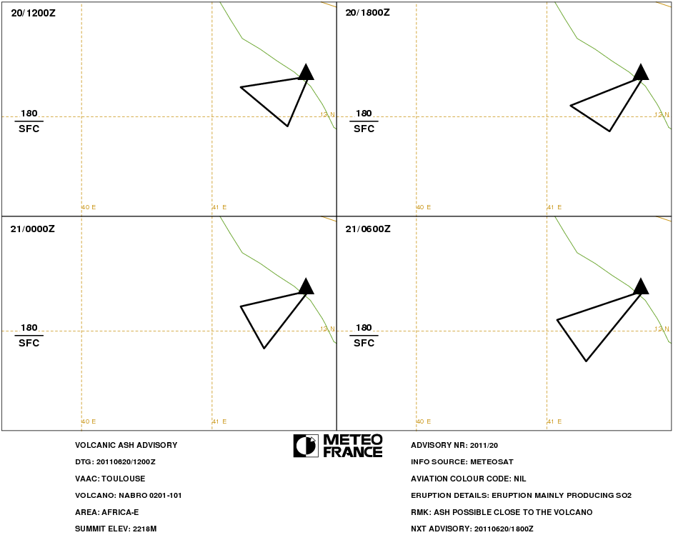
Overall the eruption of Nabro volcano in Eritrea seems to have been going through a quieter phase over the past two days, with rather small plumes (or none at all) visible in satellite images and little evidence of further explosive activity. Toulouse VAAC issued two advisories yesterday, the first at 1200 UTC reported ‘eruption mainly producing SO2’ with a small ash cloud at FL180 (18,000 feet/5,500 metres altitude) extending to the WSW/SW of the volcano, and the second at 1800 UTC reporting ‘eruption ongoing’ with no identifable ash emission: ‘only SO2 detected since 1230Z’. The sulphur dioxide emissions from Nabro have been on a very large scale: with reference to data from last week NASA reported that ‘On June 13, OMI captured high SO2 concentrations – exceeding thousands of Dobson units – from the eruption of Nabro (Eritrea) on June 12th. Total tonnage is estimated to exceed 1Tg’. There have of course been significant further SO2 emissions from Nabro since that report was written on 16 June. A gallery of Aura/OMI SO2 data for Afar showing the size and movement of the SO2 plume from Nabro can be viewed at NASA’s Goddard Space Flight Center global SO2 monitoring site. The image at the top of the post shows the SO2 plume detected by Aura’s OMI on 19 June 2011.
NASA satellite images from yesterday show the presence of a small plume over the seat of the eruption with no significant downwind emissions cloud visible. Below are images from Aqua (top) and Terra (bottom): in each case click on the image to go to the original at the NASA Rapidfire site.
")
Above. Nabro volcano, Eritrea, captured by NASA’s Aqua satellite on 20 June 2011, 1050Z. Scale: 1px = 500m.
")
Above. Nabro volcano, Eritrea, captured by NASA’s Terra satellite on 20 June 2011, 0750Z. Scale: 1px = 500m.
A dark patch is visible on the surface to the SW of the volcano. The atmosphere is murky and it is difficult to see precisely what this is: it looks too fuzzy at the edges and too brown in colour to be a lava flow. Burnt vegetation? An ash deposit? Below is a close-up from the Terra image:
")
Above. Nabro volcano, Eritrea, captured by NASA’s Terra satellite on 20 June 2011, 0750Z. Scale: 1px = 250m.
The human impact of the eruption is starting to become clearer, althouth reports from the area affected by the Nabro eruption have been hard to come by: even in this modern age communications can be difficult in this part of the world, the political character of the region tends not to encourage the free spread of information, and enduring tension between Ethiopia and Eritrea does not help. However, an article in the Ethiopian business newspaper Addis Fortune published yesterday (although the date ’12 June 2011′ confusingly appears at the top), ‘Eritrean volcano erupts economic mayhem for Ethiopia’, gives some idea of the problems the eruption has been causing across the area: flight delays and cancellations, potential health problems, and the poisoning by SO2 of local salt deposits formally exploited for consumption. The report also refers to ‘small eruptions in Afambo and Sireru areas’ as well as ‘the major eruption at Nabro’, although it is not clear precisely what’s being described here: earthquake activity, perhaps, rather than ‘eruptions’. The BBC, meanwhile, reports on appeals from aid organizations for help for the local people in Ethiopia: the inhabitants of villages in the Biddu region near the border ‘have been left without food and traditional springs and streams have been polluted’. Teshome Assefa of Save the Children tells the BBC, ‘Many community members and especially children are reported sick and in desperate need of medical attention’. It’s good to see the BBC reporting this, not so good that more than a week into the eruption they still haven’t got the name of the volcano right (‘Dubbi’ again). [Update: the BBC has corrected its report: Nabro. Thank you.]
In Eritrea itself official news on the eruption has been sparse. A brief bulletin was issued by the Eritrean Government Ministry of Information at the beginning of the eruption stating that there had been no loss of life or any other ill-effects. It seems, however, that there have been evacuations from the affected area within Eritrea, according to a further brief announcement made on 16 June:
Assab, June 16, 2011- The inhabitants of Afambo, Nebro and Sireru have disclosed that they have been moved to a safer location. Pointing out that there were occasional quakes in their areas, the inhabitants thanked the government for the fast relocation after the eruption, as a result of which there were no causalities [sic]. It is to be recalled that the eruption of June 12th around the areas of Afambo, Nebro and Sireru released large quantities of dust and smoke and the quake of 5.7 Richter it caused was felt in our region.
On the subject of earthquakes, the staff at the Observatoire Géophysique d’Arta (OGA) in Djibouti are clearly working very hard to keep track of the seismic activity in their northern neighbour and are providing the best coverage they can via their website. Today a strapline on their front page reports a decrease in tremors, with ‘few earthquakes on the Nabro volcano site’, but there are no details as yet.
News
Eritrean volcano erupts economic mayhem for Ethiopia – Addis Fortune, 20 June 2011
Eritrea volcano ash hits Ethiopia villagers – BBC News, 20 June 2011
Information
Global Volcanism Program: Nabro – summary information for Nabro (0201-101)
Nabro volcano before the eruption, at the NASA Earth Observatory 20 June 2011
Posted by admin in Africa, Eritrea, Nabro, NASA Earth Observatory.comments closed
Image of the Day at the NASA Earth Observatory for 20 June 2011 is this photograph of Nabro caldera before the current eruption. The image was captured by an astronaut on the International Space Station on 30 January 2011 (we had a preview of the image here last week, thanks to our friends at NASA).
")
The horseshoe shape of the caldera, opening to the south-west, is clearly visible, with cinder cones to the west (lying between Nabro caldera and its neighbour, Mallahle) and their dark lava flows. There is also evidence of human habitation in the western part of the caldera, with fields, houses and paths discernible in the high definition image. The area is perhaps not so desolate and barren as some reports have suggested. One can only hope that those living nearby received enough warning from the precursory earthquakes to get themselves clear before the eruption began.
Click on the image to go to the original at the NASA Earth Observatory.
A look at Nabro’s history 19 June 2011
Posted by admin in Africa, Dubbi, Eritrea, Erta Ale, eruptions, Ethiopia, Nabro, volcanoes.comments closed
Nabro is a little-known volcano. Its remote and inhospitable location has meant that very limited fieldwork has been carried out, and much of what we do know comes from remote sensing. Pierre Wiart and Clive Oppenheimer have analysed much of what is known about Nabro in a very useful paper published in the Bulletin of Volcanology in 2005: ‘Large magnitude silicic volcanism in north Afar: the Nabro Volcanic Range and Ma’alalta volcano’. The article is based upon remote sensing data and very limited fieldwork: thus eruptive sequences are established with reasonable clarity, but there is little dating information.
The authors note that much research on north Afar has focused on Quaternary basaltic volcanism, but that silicic volcanism in the region has been little considered, although ‘comparable volumes of silicic magma [compared with basaltic] have been erupted in the region’ (99). The Nabro Volcanic Range (NVR), which the authors identify as a single volcanic massif covering approximately 110 km and trending SSW-NNE from the Afar Depression to the Red Sea, is one significant but little-studied focus of silicic activity. The NVR encompasses the Edd Islands off the Red Sea coast, Dubbi volcano and the Edd lava field, Mabda volcano and the Bidu volcanic complex (Nabro and Mallahle calderas, and Bara Ale and Sork Ale volcanoes). The paired calderas of Nabro/Mallahle are described as follows:
Nabro has an 8 km diameter horseshoe-shaped caldera breached to the SW, and facing the 6 km diameter caldera of Mallahle. Nabro’s caldera contains a young volcanic centre, topped by two additional collapse craters. The flanks of the volcano are strongly dissected by gullies, whereas the inner walls of the caldera form 400-m high cliffs. The older of the two craters inside Nabro’s main caldera is also horseshoe-shaped and similarly open towards the SW. The walls of the innermost crater are 200 m high. (102)
Nabro and Mallahle are described as very similar in geomorphology and lithology, both being predominantly composed of trachytic lava flows. ‘On Nabro, geochemical and spectral evidence highlight at least two main periods of eruption of these flows’ (103). Both basaltic and silicic products are evident: ‘Whereas the main periods of edifice growth, collapse, and post-collapse volcanism have been characterized by silicic products, later volcanics of the Bidu Volcanic Complex include NNW-SSE basaltic lava flows, which streamed from vents or fissures located between the two calderas’. The authors suggest that these flows probably tapped separate source regions to those that fed the silicic volcanism, and note that ‘their superimposition on the boundary between the two calderas and orientation (i.e., perpendicular to the NVR axis), are enigmatic, but clearly not coincidental’ (103).
A very large eruption or eruptions in the past is evidenced by the presence of extensive ignimbrites, which the authors believe are ‘associated with collapses of both Nabro and Mallahle that formed the present day calderas’ (103). The age of these ignimbrites is unknown, but their spectral characteristics and state of preservation suggest their creation in a single eruptive sequence. The present-day ignimbrites cover an area of ~600 square kilometres, with a bulk volume tentatively estimated at 20 cubic kilometres. Prior to erosion of course a much greater bulk must have been present: the combined ignimbrite outcrop today lies within a 30 km radius of Mallahle, and the authors propose that if there was originally a single ignimbrite sheet extending this distance with a mean thickness of 40 m, the eruption magnitude may have exceeded 100 cubic kilometres (bulk volume):
These speculative upper and lower bounds on the ignimbrite volume [20-100 cubic kilometres] suggest an eruption (or eruptions) comparable in magnitude to the largest known historic eruption, that of Tambora in Indonesia in 1815, which expelled around 50 km3 of (dense rock equivalent) magma. This inference is compatible with the comparable caldera dimensions of Tambora (6 km), Nabro (8 km) and Mallahle (6 km). (107)
The total volume of the NVR is estimated by Wiart and Oppenheimer to be ~550 cubic kilometres, broadly comparable to that of Erta Ale. Overall they conclude that ‘the Erta’Ale range and NVR are, therefore, of broadly comparable area, volume, and age (Quaternary)’ but differ markedly in their composition and eruptive nature, with the Erta Ale range being composed of 91.4% basalt, 8.1% dark trachyte and 0.5% rhyolite, while the NVR is estimated as being 50% composed of trachyte and rhyolite (109). The authors suggest that the nature of the basement is responsible for this difference in composition, with the presence of continental crust on the margin of the Danakil region promoting the evolution of volatile-rich and ultimately explosive magmas.
The overall picture of Nabro is of a complicated and fascinating volcanic complex with a violent but varied history involving both explosive and effusive activity, some of the latter being possibly relatively recent in date, and set apart from the more northerly Afar volcanoes by its greater involvement of silicic and explosive magmas. The current eruption involved some initial explosive activity, but appears to have subsequently settled down to an intermittent and relatively low-level effusive event. It is to be hoped that clear images from the satellites will soon show the extent of the lava flows, and their sources. Given the evidence of Nabro/Mallahle’s history, it could be that their sources lie between the two calderas, replicating the behaviour which seems to have characterized the most recent activity at this obscure and intriguing volcano.
N.B. Several people have been in touch or left comments here to say that the Wiart & Oppenheimer paper is freely available via ‘a well-known file hosting site’. However, the paper in question is copyright Springer-Verlag 2004, and this blog respects copyright. Accordingly I won’t be providing the link here, and I respectfully ask that no-one else does so via the comments.
Reference
Pierre Wiart and Clive Oppenheimer, ‘Large magnitude silicic volcanism in north Afar: the Nabro Volcanic Range and Ma’alalta volcano’, Bulletin of Volcanology, vol. 67, no. 2 (2005), pp. 99-115 [DOI: 10.1007/s00445-004-0362-x]
Information
Global Volcanism Program: Nabro – summary information for Nabro (0201-101)


