The ecological impact of the Chaitén eruption 27 October 2009
Posted by admin in Chaitén, Chile, eruptions, natural hazards.Tags: Chaitén, Chile, South America, volcanic eruptions
trackback
What follows is a guest post and photo essay (10 images) by Frederick J. Swanson (U.S. Forest Service), Charlie Crisafulli (U.S. Forest Service), Julia A. Jones (Oregon State University) and Nicolas La Penna (Chaitur Excursiones).
+ + + + + +
Deservedly, Chaitén volcano at 43° S in Chile has been a popular subject on The Volcanism Blog, but mostly viewed via remote sensing from space or the plume surveillance camera. To give a feeling for on-the-ground conditions, we offer a short photo essay from travels to the area in March 2009 to carry out reconnaissance on ecological effects of the May 2, 2008, eruption. One of our study objectives was to compare ecological responses to the eruption of Chaitén with those observed in the intensively-studied Mount St. Helens landscape since her May 18, 1980, eruption (Dale et al. 2005).
Chaitén and Mount St. Helens have some important similarities in the suites of volcanic processes involved in their major eruptions – lateral blast, tephrafall, and lahars – as well as high levels of water and sediment runoff from tephra-mantled hillslopes (Lipman and Mullineaux 1981, Carn et al. 2009, Lara 2009). (Note: ‘blast’ is used here as a general term for a laterally-directed, rapid movement of sediment-charged air; clearly the volcanic processes were quite different.) The recent eruptions at these two volcanoes differed in several respects, including much more extensive blast and lahars at Mount St. Helens and what appears to be much more extensive forest canopy damage in response to tephrafall at Chaitén. Further, and of substantial ecological importance, were differences in particle size of tephras between the two volcanic eruptions. Mount St. Helens tephra was coarse dacite pumice, whereas Chaitén tephra was very fine rhyolite ash. At both volcanoes these processes have created gradients of disturbance in the forests ranging from complete removal of aboveground vegetation to toppling of trees to killing of standing trees by abrasion and scorching of foliage to a gentle deposition of cool tephra into living forest. Stream and river habitats near the volcano also experienced a range of disturbances, including inundation by fine tephra washed from the hillslopes and severe scour by lahars and floods augmented by rapid runoff from tephra-covered hillslopes. These fluvial processes severely damaged the town of Chaitén and triggered evacuation of its 5000 residents.
As at Mount St. Helens, the severely impacted Chaitén landscape at first appeared lifeless, but we quickly found organisms surviving in a variety of ways and in many locations. Several types of understory plants, such as ferns, nalca, and bamboo, sprouted vigorously from belowground rootstocks. Several species of broadleaf trees, both standing and toppled with limbs removed, were beginning to sprout along the bole. We were surprised by the paucity of evidence of animals, including insects, spiders ballooning in on the winds, birds and burrowing animals, such as the rodents and ants which were common at Mount St. Helens in the first summer after the eruption. More detailed reports from Chaitén are forthcoming; observations at Mount St. Helens are documented in Dale et al. (2005).
The following photographs show three zones along the gradient of forest disturbance and a sampling of river conditions in the vicinity of Chaitén in late March 2009. [There are ten images. Click on each image to view a larger version.]

Figure 1. Remote sensing image showing locations of photos (numbered), Chaitén volcano (CV) and town (CT), and Minchinmávida volcano (M) with its extensive ice cap. Note that rivers on the north, east, and south sides of Chaitén drain from Minchinmávida; Chaitén’s relatively diminutive stature (ca. 1000 m before the 2008 eruption) precludes generation of massive, long-runout lahars. Tephrafall east of the volcano has caused browning of foliage of the forest, especially on upper slopes. The blast-affected area on the northwest flank of the volcano has a sharp boundary with green forest vegetation. (Source: Int’l Space Station, Feb 24, 2009, Astronaut photograph ISS018-E-35716) [Click on the image to enlarge.]

Figure 2. View from above the vent toward the northwest in May 2008 several weeks after the eruption. The Rio Rayas flows to the west across the top of the photo. Blast-toppled forest is in the near-ground, fringed by a narrow zone of scorched canopy and then the live forest in the upper half of the photo. National Highway 7 crosses the image. Numbers indicate photo location, arrows indicate direction of photo view in subsequent images (3, 4, and 7). (photo: A Lockhart, US Geological Survey) [Click on the image to enlarge.]

Figure 3. Blast-toppled forest on northwest flank of Chaitén. Lara (2009) describes this process as ‘minor column-collapse pyroclastic flows’ during the first week of the eruption. In this view trees are toppled from right (the vent) to left. Standing, blast-killed forest is in the distance on left side of image. (photo: C Crisafulli) [Click on image to enlarge.]

Figure 4. Blast-killed forest at boundary between the toppled-forest zone (in distance toward the volcano) and the standing dead zone. Small patches of sprouting ferns are in the middle distance to right of camera. (photo: copyright N La Penna) [Click on image to enlarge.]
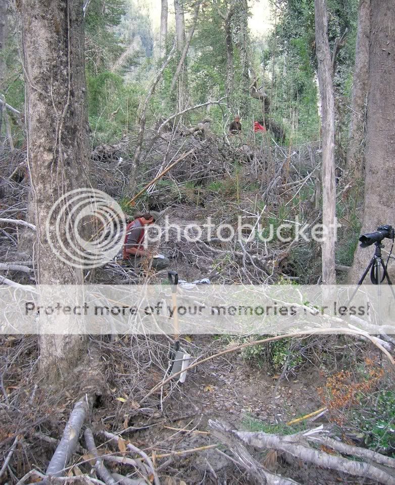
Figure 5. Tephrafall zone with approximately 20 cm of tephra deposition (as of March 2009) 30 km downwind from the vent. Note surviving trees, but large amount of limb debris and tree tops dropped by the weight of tephra in the canopy. (photo: F Swanson) [Click on image to enlarge.]
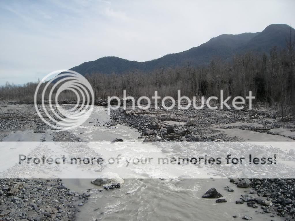
Figure 6. Rio Rayas looking downstream from the Highway 7 bridge. Aggregations of logs freshly deposited along the channel margin suggest major, post-eruption flooding, influenced in part by rapid runoff from slopes blanketed by very fine-grained tephra in the source watershed. Forest to the right (north) appears to have been killed by the scorching heat of the blast. Turbidity may reflect discharge from Minchinmávida glaciers in the headwaters of the river as well as tephra mobilized from hillslopes throughout the contributing watershed. (photo: F. Swanson) [Click on image to enlarge.]

Figure 7. Rio Gigios looking upstream from Highway 7 bridge toward the rim of Chaitén’s caldera in the distance. Blast-scorched, standing-dead forest occupies the adjacent banks and toppled forest covers hillslopes in the distance. The channel in the foreground was modified first by high runoff and perhaps debris flows from the mountain side and then by heavy equipment in an attempt to sustain the bridge. (photo: J Jones) [Click on image to enlarge.]
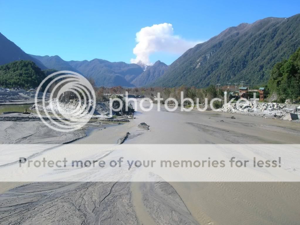
Figure 8. Rio Blanco (also called Rio Chaitén) on the bridge into Chaitén town looking north to the steaming domes of Chaitén volcano 10 km away. Lahars, floods, and pyroclastic flows have altered the channel and killed floodplain vegetation. The river heads at glaciers of Minchinmávida and the watershed drains a zone of thick tephra deposition. Tephrafall into the forest canopy to the right (east) has killed foliage in upper slope forests. March 24, 2009. (photo: C Crisafulli) [Click on image to enlarge.]
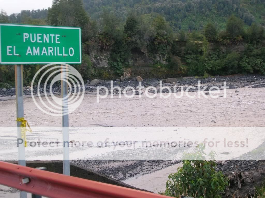
Figure 9. Rio Amarillo (at the town of Amarillo) flowing from Minchinmávida, its icecap, and an extensive forested landscape with tens of centimeters of tephrafall. The far bank exposes deposits of lahar, fluvial, and pyroclastic flow origin, including large pieces of wood, recording aspects of the history of Minchinmávida. March 27, 2009. (photo: F Swanson) [Click on image to enlarge.]

Figure 10. A tributary to Rio Amarillo draining a watershed with substantial tehprafall. Floodplain forest appears to have been killed by deposition of sediment (mainly fluvially transported tephra) and associated rise of the water table. (photo: J Jones) [Click on image to enlarge.]
Copyright notice
With the exception of Figure 4, which is copyright N. La Penna, all text and images in this blog post are in the public domain.
References cited
Carn S. A., J. S. Pallister, L. Lara, J. W. Ewart, S. Watt, A. J. Prata, R. J. Thomas, and G. Villarosa. 2009. The unexpected awakening of Chaitén Volcano, Chile. Eos Trans. AGU 90(24):205-206.
Dale, V. H., F. J. Swanson, and C. M. Crisafulli. 2005. Ecological Responses to the 1980 Eruption of Mount St. Helens. Springer, NY.
Lara, L. E. 2009. The 2008 eruption of the Chaitén Volcano, Chile: a preliminary report. Andean Geology 36(1):125-129.
Lipman, P. W., and D. R. Mullineaux. 1981. The 1980 eruptions of Mount St. Helens, Washington. US Geological Survey. Prof. Paper 1250.
– – – – – –
Frederick J. Swanson, US Forest Service, Pacific Northwest Research Station, Corvallis, OR, USA (corresponding author: fswanson@fs.fed.us)
Charlie Crisafulli, US Forest Service, Pacific Northwest Research Station, Amboy, WA, USA.
Julia A. Jones, Geosciences, Oregon State University, Corvallis, OR, USA.
Nicolas La Penna, Chaitur Excursiones, Chaitén X Region, Chile.
+ + + + + +
For all Volcanism Blog coverage of the Chaitén eruption: Chaitén « The Volcanism Blog.

Comments
Sorry comments are closed for this entry


Any information upon the impact of water quality to the region? The Michinmauida Glacier turned gray from ash deposits. The Michinmauida spawns several rivers that people and animals depended on for water.
Thank you so much for this valuable information posted in your blog. For over a year and half we have seen little presence of the scientific community in our area .
Although most of the attention has been placed in the socio-economics and geo-political impact of this amazing natural phenomena, we strive for scientific evidence which will help us in the decision making process when protecting our love ones, property, tourists and livelihood.
Thank you for keeping us informed.
Robert, our group from New Zealand visited the area in Jan/Feb 09 (ie around nine months after the start of the eruption) and collected data on surface water quality, among other things. If you’d like to email me at stewart.carol@xtra.co.nz I’ll send you a pdf of the poster we just presented at GSA.
By the way, thanks Fred & co for posting this article – it’s great.
BIEN CHAITEN LODGE (Enrique).
SALUDOS
PABLO